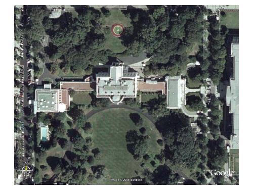
They should fire the reporter and the sub-editor: after reading this, I made what was only a cursory check and found that nothing of the White House (or any area around it) has been blanked out! In fact, neither have any of a number of other landmarks/ installations which can be counted as important – and this is all around the world, not just in the US, UK or India! In fact, as any user of Google Earth could have told these guys, metropolitan areas of the US are the ones that are covered in greatest detail. Times of India has been floundering on quality metrics for a long time now but this really takes the cake in both sloppy reporting and drawing asinine conclusions.
This is no big deal – and it is just the FREE version available to anyone around the world with a high-speed connection to the internet. There are more detailed views out there for anyone willing to pay relatively small sums of money for it and importantly, from a national security perspective there’s yet more advanced versions available with our enemy’s militaries! Technology is all around us: and it is for us to choose whether we want to use it – to educate our children, empower our entrepreneurs and serve our citizenry – or want to remain "blanked out" from the forward ranks of development.
And finally, with journalists like these (who are more concerned about "blanking out" than with shedding light on things), it is little wonder that we have taken forever to pass the Right to Information Act and struggle to implement it in letter and spirit.
N.b.
Where the mind is without fear and the head is held high;
Where knowledge is free;
Where the world has not been broken up into fragments by narrow domestic walls;
Where words come out from the depth of truth;
Where tireless striving stretches its arms towards perfection;
Where the clear stream of reason has not lost its way into the dreary desert sand of dead habit;
Where the mind is led forward by thee into ever-widening thought
and action --
Into that heaven of freedom, my Father, let my country awake.
Rabindranath Tagore
3 comments:
i thinku hit d bulls eye here..!! :-) Indian media needs to get positive..!!
random chord: that's only because they're progressively upgrading pictures all over the world. The "common questions" page on their site has the following to say:
"The whole world is covered with medium resolution imagery and terrain data. This resolution allows you to see major geographic features and man-made development such as towns, but not detail of individual buildings. Additional high-resolution imagery which reveals detail for individual buildings is available for most of the major cities in the US, Western Europe, Canada, and the UK. 3D buildings are represented in 38 US cities (the major urban areas). Detailed road maps are available for the US, Canada, the UK, and Western Europe. And Google Local search is available for the US, Canada, and the UK" and "Google Earth combines data of different resolutions to offer a seamless viewing experience, so some locations look a bit blurry. We offer high resolution imagery (greater than 1-meter) for thousands of cities and more are on the way" (Emphasis provided)
Heck, leave aside American cities for a moment. Baghdad, Fallujah, and other Iraqi cities -- where U.S. forces are actively engaged in hostilities as I write -- are viewable on Google Earth in all their detailed glory. If there is justification for the U.S. government to block the enemy from obtaining detailed terrain maps, it would be strongest here. But it hasn't been done yet.
This is not to say it could never be done. There is no constitutional bar to the gov't shutting down this kind of free mapping service in the name of national security. Yet keeping such a service alive is a political choice I believe Americans will keep on making, barring some horrific outcome.
The Register has quoted a number of military officials, including an Indian one, as saying that this kind of widespread information is now a technological reality with which they have to contend and plan around. There's no putting this genie back into its bottle. The TOI and its readership had best get used to it. I know it's a big leap to make, especially in countries like India and Pakistan where "strategically sensitive maps" of wide swaths of land have always been carefully guarded and off-limits to the public, but I don't think there's much of a choice anymore.
Post a Comment